
On his first trip to South America, our writer discovers how Chile’s land, along with its Indigenous communities and history of immigration, has shaped a unique identity
Words & photographs Elliot Wellsteed-Crook
Natural highs (top to bottom) The Cuernos del Paine (The Horns) is the name given to a set of 2,000m-high granite peaks in Torres del Paine National Park; Atacama is the world’s driest non-polar desert; the historic Plaza de Armas in Santiago
Geographically, Chile is a country of extremes. As one of the world’s narrowest nations, it stretches around 4,300km but averages barely 180km in width. Some formidable natural borders wrap this slim expanse: to the north lies the Atacama, the driest non-polar desert on Earth; to the west is the vast Pacific Ocean; to the east are the mountains of the Andes, which wall off neighbouring Argentina; and to the south are the glaciers, frozen peaks and arid steppe of Patagonia.
With my ten-day itinerary in hand, I set out to explore Chile from north to south. But what surprised me was how this country is shaped as much by its relentless geography as by its people. These landscapes have moulded cultures, communities, entire industries and history across generations.
Until the arrival of the Spanish, these lands largely thwarted even the empires of Latin America, though both the Tiwanaku and Inca held sway in the north. Instead, this is the ancestral home of a plurality of Indigenous peoples, many of them grouped under the name Mapuche (‘People of the Land’). Those of central and southern Chile even resisted Spanish colonisation until deep into the 19th century.
This land has shaped Indigenous cultures and traditions for centuries, and its communities remain fierce protectors of it. Lickanantay (Atacameño) people learnt to make their home in the desert oases and high-altitude plateaus of the north, while in the south, Kawésqar communities thrived in the harsh conditions of Patagonia, travelling its fjords in bark canoes.
The stories of the Indigenous peoples of Chile, together with the Europeans and West Asians who arrived from the mid-19th century onwards, are deeply intertwined with these landscapes. And as I travelled, I began to see the land and its people as part of one great unfolding narrative.
Plaza de Armas was established by Pedro de Valdivia in 1541

Diversity here doesn’t just extend to the people and their lands; you can experience almost every climate, too, along with the unique food and drink this produces. I started my journey at Santiago’s lively Mercado Central, the city’s main market since 1872. At El Galeón, a local dining favourite, head chef Sebastián Del Gardo greeted me with a glass of what he called ‘Chilean Viagra’, a local take on the pisco sour, made with grape brandy, lemon and sugar.
“People in Chile work hard,” Sebastián said, “and you need something to get you up.” His words captured the grit, graft and humour I saw everywhere I looked as the market buzzed around us. Piles of fruits and vegetables of every shape and hue were stacked high and glistened appetisingly, while the scent of fresh seafood trucked in from the coast that day wafted across the stalls.
The market’s structure is made of iron, a resource that is abundant in Chile’s arid north. Standing beneath its wrought-iron rafters, Sebastián shared the highly entertaining (and entirely false) urban legend that Santiago’s market was once “stolen by Montevideo”.
It turned out that the iron used to build the Mercado Central was mined in Chile, but the country lacked the skills to forge it. An engineering firm in Scotland was hired to prefabricate the structure, which was shipped to the port city of Valparaíso. The myth arose because several prefab iron buildings were exported to cities across South America, and the tale of a “stolen” market took on a life of its own.
Catedral Metropolitana de Santiago, an example of colonial architecture, in the city’s central square, the Plaza de Armas
Beyond the market and its myths, Santiago proved endlessly surprising. I was shocked that the capital’s historic downtown still lacked UNESCO World Heritage status. Too often, the city is seen as a stopover or downgraded to a brief stay. And while its charms are more subtle than some other South American hubs, such as Cusco or Cartagena, this sprawling metropolis, set against the towering backdrop of the Andes, is ripe with stories.
It was in Santiago that the Spanish founded the country’s colonial capital in 1541. A legacy of its early days under Spanish rule can still be seen in the architecture of the historic centre and in its central square, Plaza de Armas. Elsewhere, in neighbourhoods such as Lastaria and Bellavista, modern independent shops, galleries and cafés spill onto streets shaded by jacaranda trees, and street art assails the walls of restored townhouses, giving vent to the city’s restless creativity.
At the Chilean Museum of Pre-Columbian Art, however, I was reminded that the capital stands on ancestral Mapuche territory. Even the Spanish didn’t have it all their own way here. Many Mapuche communities long resisted colonial expansion, maintaining their independence until the late 19th century in spite of the growing European presence – an extraordinary feat in the history of the Americas.
Mapuche territory is strongest in the Araucanía region, south of Santiago. Their presence is still visible in the capital through the crafts sold at markets; however, the debate around land and cultural recognition continues to shape Chile’s political conversation. The Wenufoye (Mapuche flag) has tellingly become not only an emblem of the Mapuche’s fight for autonomy, but also a widespread symbol of resistance against inequality.
The iron roof of the Mercado Central; Santiago Metropolitan Cathedral; Sebastián Del Gardo; Mercado Central was opened in 1872
I sadly missed out on…
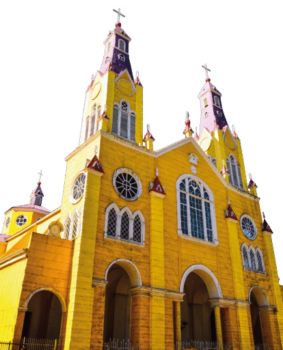
Chiloé Island is often called a microcosm of Chile. Here, wild coastal landscapes meet a culture shaped by isolation. Wooden churches, several of them UNESCO-listed, loom above rolling pastures and fishing villages on stilts. Charles Darwin even stayed here in the 1830s, stopping off on his voyage on the HMS Beagle to study its wildlife, including the island’s unusually small fox species. The observations he gathered helped to form his theory of natural selection.
Leaving Santiago behind, I journeyed 120km west to another melting pot: the Pacific port of Valparaíso. Its name translates as ‘Paradise Valley’, a nod to the dream-like appeal the port once held for arriving immigrants. Today, its UNESCO-listed historic quarter remains an eye-catching centrepiece in this ‘city of hills’. Houses and streets are stacked across 45 cerros (hills), their walls decorated with thousands of murals and colourful graffiti. It’s no wonder that the poet and national treasure Pablo Neruda chose the city as one of his bases in the mid-20th century. His former house, La Sebastiana, is now a museum that looks out over the bay.
Neruda wrote: ‘Valparaíso, what a nonsense you are. What a crazy port, what a head of dishevelled hills… You are the pirate’s hiding place, the bird’s nest of the ocean.’ The line captures the chaotic charm of Valpos, as locals call it, a city built on its unique geography and creative, resilient people. But beyond Valparaíso’s sultry good looks lies a long history of immigration.
The story of the arrival of Europeans and West Asians is told at the Immigration Museum, which opened last August. It uses multimedia to share hundreds of stories honouring immigrants and their descendants – the people who shaped the city’s identity.
In the 19th century, an influx of new arrivals, notably from Lebanon, Syria and Palestine, descended on Valparaíso. They brought with them expertise that fuelled the city’s buoyant industrial chapter. Steamships, railways and cranes were built by immigrant workers using Chilean materials. One of the world’s earliest submarines, an engineering miracle of its time, was even built here. And while it ultimately sank, it became a symbol of the daring imagination of those who came to the city seeking a better future.
Chile’s immigration story continued as I travelled 1,000km south. Looking out at the cold sea near Puerto Montt, close to the Chilean Lake District, my guide, Matias Valenzuela, explained to me how the region changed dramatically in the 19th century with the arrival of a wave of German settlers.
“Chile needed people to develop its lands,” he told me. “They approached Germany, which didn’t have much of an empire at the time. The choice was more about geopolitics than ideology, though it helped that the Germans could handle the tough weather.”
The settlers turned away from the urbanisation and industrialisation sweeping Europe and built the picturesque city of Frutillar on the shores of Lake Llanquihue. Even today, it maintains a strong Germanic character in its steeply pitched roofs and Bavarian-style wooden architecture.
Just outside Puerto Montt, I found another remarkable story of immigration at the Palaeolithic archaeological site of Monte Verde, where the remains of an early human settlement were found in 1975. The significance of this discovery rippled far and wide because it overturned the ‘Clovis first’ model, which had held that the first humans who arrived in the present-day Americas did so via a Siberian land bridge around 13,000 years ago. Evidence here indicated that humans had settled at least 1,500 years earlier. It is a reminder that, beyond the modern immigration story, communities thrived in this region for millennia.
In the city of Puerto Natales, gateway to Torres del Paine National Park, many Europeans arrived at the dawn of the 20th century. The Chilean government leased and sold large tracts of land at low prices to help them start farms and businesses. However, Chile’s immigration story slowed thereafter, as the opening of the Panama Canal, war and earthquakes hit exports hard. It only picked up again in the late 1970s, when the south became a hub for salmon production.
(clockwise from top left) The pale waters of Lake Pehoe glitter beneath the Cuernos del Paine; a mural in Puerto Natales depicting the cultural heritage of the Aonikenk and Kawésqar peoples; an early prototype submarine built in Chile; a monument in Puerto Montt commemorating the 200 German settlers who arrived in the region at the end of 1852; street art in Valparaíso blossomed as a form of civil disobedience in the 1970s after General Pinochet banned all forms of subversive art
Chile is the world’s second-largest exporter of farmed salmon after Norway, thanks to the fjords and channels of the south coast that make it ideal for fish farming. As I gazed out from Puerto Natales at the spidery network of islands offshore, it occurred that this was yet another example of the environment shaping life. The south’s harsh climate and vast landscapes have created a tight-knit community steeped in hard work and neighbourliness. But it was not always this way.
Just north of Puerto Natales, Torres del Paine is the crown jewel of Chilean Patagonia and a paradise for anyone who wants to see nature at its grandest. I’d come here to do some trekking, including a visit to the immense Grey Glacier, a 6km-wide river of ice that towers around 30m high. The sheer scale of it was breathtaking.
But beyond the scenery lies a darker past. As the Patagonian steppe fell under the control of vast estancias (farms) in the late 19th and early 20th centuries, the lands around Torres del Paine were seized. The Aónikenk and Selk’nam peoples, who had lived here for millennia, were tragically either displaced, killed or fell to disease.
Today, little in the landscape hints at that history, but understanding it adds a deeper resonance to Patagonia’s cold beauty. It is yet another tale of survival, loss and resilience in a land where geography still rules over people.
Worth reading up on…
Travelling in Chile often felt like a geology lesson. In the Chilean Lake District, I learnt why the perfect cone of Osorno contrasts with the much older, broader peaks around it. Further north, I discovered that the collision of the Pacific and South American tectonic plates forced seawater deep underground, forming the salt flats and mineral-rich, copper-red earth. And in Patagonia, I learnt that the towers of Torres del Paine began underwater and were shaped by magma rising through the seabed, giving rise to their dramatic outline. Understanding Chile’s geology makes its beauty both meaningful and breathtaking.
Chile’s most surreal landscape lies in the north. The Atacama Desert, often dubbed one of the driest places on Earth, feels more like something from another planet. But this vast emptiness has an all-too-human history.
Until the late 19th century, much of the Atacama was in Bolivia’s hands. After the War of the Pacific, Chile emerged victorious and took control of the mineral-rich desert, leaving Bolivia landlocked. It is a loss that is still keenly felt. Meanwhile, Chile’s newly gained nitrate deposits (used in fertiliser and explosives) sparked a boom that changed the young republic’s fortunes.
The region’s abundance of mineral resources offers something for visitors, too. Around the ochre-hued town of San Pedro de Atacama, the wealth of minerals gives the desert a ruddy look that feels almost extraterrestrial. The terrain is so similar to that of Mars that scientists come to rehearse space missions, and NASA has even used it to test Mars rover prototypes.
Salt flats and cracked rock formations roll mile after mile beneath mountains and volcanoes that rise over 5,000m. At El Tatio, one of the world’s highest geyser fields, I saw plumes of steam hiss into the thin air as the Andes glowed pink in the dawn light.
(clockwise from top left) The town of Frutillar was founded in the 1850s by German families encouraged to colonise the area because the government wanted to develop the land; lupins were brought to Patagonia by the British, and their seeds were spread across the region by sheep and cattle – another reminder of how people and geography have shaped the area; the author does some horse riding in Patagonia; peering over the Valle de la Luna, an otherwordly symphony of stone and salt sculpted across millennia; eerie landscapes abound among the high-altitude desert of the Atacama
But for all its otherworldly appearance, the Atacama is far from lifeless. Above the valleys, I spotted Andean condors riding the thermals, their vast wingspans casting shadows over the desert floor. On the altiplano, the world’s second-highest plateau, I saw herds of wild vicuña (the delicate, cinnamon-coloured cousins of the llama) graze on sparse tufts of ichu grass, which changes colour according to the altitude, as Atacama foxes darted between scrub and rock.
I also saw flamingos gather in lagoons that sit at 2,500m above sea level. These creatures are remarkable migrants, travelling vast distances across the Andean plateau in search of breeding grounds. As I watched a flock sift plankton from the briny water, my guide Rodolfo told me, only half-joking, that “every time you buy a smartphone, a flamingo dies”.
Lithium – another mineral found here in abundance – is extracted by pumping the mineral-rich brine beneath the salt flats to the surface and then evaporating it. It is a process that reduces water in what is already one of the driest regions on Earth. Conservationists warn that falling groundwater levels could threaten the fragile lagoons where Andean, Chilean and James’s flamingos feed.
However, the Atacama is also where wildlife, geography and people come together. Therein lies hope. The Lickanantay people have lived here for millennia, developing irrigation systems and ancient trade routes long before modern borders were drawn. Today, they are the stewards of the land, and many work as guides, attempting to balance tourism and the preservation of this fragile ecosystem.
As lithium mining continues to threaten the stability of the salt flats and local water resources, the Lickanantay are central to the debate around environmental protection. Whether through land disputes or minerals, ancient trade routes or environmental concerns, the Atacama attests to the story that even in a land that appears empty, geography and people remain inseparable.
(top to bottom) Condors, flamingos, rabbit-like viscachas and Atacama foxes can be seen in the high-altitude altiplano of Chile’s arid north, the second-highest plateau in the world, which is home to much more wildlife than you’d expect given its harsh conditions; the lively main street of San Pedro de Atacama in the deep north was part of Bolivia until the Atacama region was lost to Chile in the late 19th century. Today, its streets are still lined with adobe buildings, giving it the feel of another era entirely, and it is a great jumping-off point for exploring the highlands and their famously pitch-black skies
Photography: Alamy; Elliot Wellsteed-Crook; Shutterstock
The author travelled with Llama Travel, which specialises in tailor-made tours to Latin America and beyond, including trips across Chile. For more information, visit llamatravel.com.


