


The 220-year anniversary of the Lewis and Clark Expedition is the perfect time to explore the national trail
An adventure is assured by following even a small portion of the Lewis and Clark National Trail. If you enjoy Americana, history, rivers and mountaineering, natural science or Native American culture, you will not be disappointed…
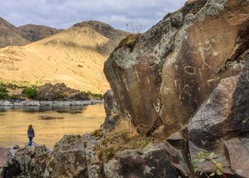
“Be careful. These rocks can be slippery!” I had been admiring my tour guide James Whitebull’s waist-length braids but then I quickly started paying attention. We were descending to the water’s edge between granite boulders that lie along the Snake River in Hells Canyon where temperatures soar during summer.
This place is known as Buffalo Eddy, where swirling currents are strong and treacherous. We were not far from the spiralling water, but this was a chance to view the ancient petroglyphs created by the Nii Mii Poo (Nez Perce) people. Were these eddies and currents as unforgiving as they looked?
“There was a time when Grandfather jumped in near here to rescue one of the children that had fallen into the water. He managed to grab the child and thrust it above his head. People in a passing boat yanked the little one in, but Grandfather was swept away.” Point made.
I was in the north of Idaho on the western side of the Bitterroot Mountain Range, not far from the confluence of the Clearwater and lower Snake Rivers. This is the land of the Nez Perce who were some of the finest horsemen in the West and bred the original Appaloosa ponies.
Investigating this part of the Snake River, which Lewis and Clark’s Corps of Discovery sailed down to connect with the mighty Columbia River, I became acquainted with the expedition’s many trials and tribulations. Ultimately, overcoming these obstacles, they arrived at the Pacific Ocean near present day Astoria. The mission to discover a route from the middle of the continent to the coast had been completed by 15 November 1805. It had taken them one year, six months, and one day.
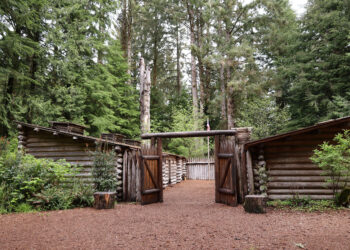
Once there, the two captains had a democratic vote amongst the crew, including York and Sacajawea, on where to set up camp. A beach, about 15 miles north of Seaside, Oregon, was chosen and tents quickly pitched to offer protection from the incessant rain. One of the coldest winters on record ensued and for a month their focus was on constructing Fort Clatsop, named for the local tribe. This would shelter them from the worst of the Pacific storms as they prepared for their return to St. Louis. After months of eating fish, they traded with the local tribe to acquire dogs for food.
Though Meriweather Lewis and William Clark completed their epic 5,955 km military campaign to find a route from the East to the ocean, technically the expedition was a failure. According to Museum Manager Aaron Webster of Cape Disappointment, WA., President Jefferson had tasked the young captains with mapping an easy river path to the Pacific. But the formidable Rocky Mountains proved an almost insurmountable barrier to completing the assignment.
The treacherous terrain encountered by the expedition would have been completely unknown to Americans living on the East Coast. President Jefferson, based in Monticello, Virginia had been dreaming of the West and the expansion of the United States for at least two decades. He and scientific friends were brimming with curiosity. For instance, was the West still roamed by Mastodons?
The President’s dream became reality with the enacting of the Louisiana Purchase, a deal Jefferson made to buy French-owned land west of the Mississippi River from Napoleon Bonaparte for $15 million. This meant the West would now be open to exploration by the US.
Meriwether Lewis, Jefferson’s private secretary, had already been accumulating supplies – food, oiled linen for tents, mosquito nets, and items for trading. Under instructions from Jefferson, he had a barge constructed with housing in the back to serve as office and sleeping quarters. A Red Pirogue and later White Pirogue (a type of large canoe) were added to the fleet. Lewis then took the barge down the Ohio River from Pittsburgh, picking up William Clark in Louisville. They decided on a location for their winter camp, to be named Camp Dubois, on the confluence of the Mississippi and Missouri Rivers. They would now assemble a group of military and frontier men with skills such as boating, hunting, fighting and cooking.
Lewis was taught to calculate longitude and latitude and took crash courses in astronomy, mathematics, botany, medicine, and science. According to author and researcher Charles G. Clarke, the group ultimately numbered as many as fifty and included York, an African American slave.
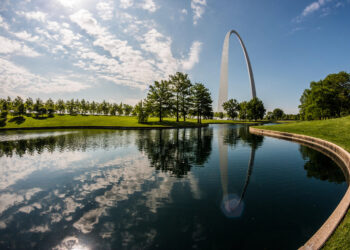
To find out more, I travelled to St. Louis to visit the Gateway Arch National Park, Missouri, and its newly refurbished premises. Of course, the 192m tall Arch constructed between 1962 to 1965 is the star of the show, with a ride to the top via a ‘tram’ with tiny pods. Though I thought it a bit claustrophobic, it offered engaging views over the city. Inside the visitor’s centre, six interactive story galleries, formerly known as the Westward Expansion Museum, honour the settlers and explorers who conquered half of a continent. There is a section on Colonial St. Louis, as well as one on Manifest Destiny, the idea of America’s God given right to populate the West. This tiny national park is now attached by an extensive lawn to the city’s historic courthouse.
About 20 miles from St. Louis lies the confluence of the Missouri and Mississippi Rivers. Very close by is St. Charles. Its historic town center lies next to the Missouri River and is dotted with restaurants, gift shops and bookshops. The Boathouse Museum, directly next to the river, has recreations of the boats used by the expedition and also focuses on what life was like in this area when the Lewis and Clark expedition took place.
The first discoveries
The expedition began on the 14 May 1804 when Lewis and Cark and their men set sail in three boats onto the Missouri River. Early in the voyage, several of the crew were surveying land in what is now the state of Nebraska when they came across a small burrowing creature which barked when alarmed. It was a prairie dog. One was killed and another captured alive to send back to Washington D.C. But this was only achieved after a significant amount of time spent pouring water down burrows to flush out a specimen.
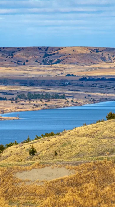
Continuing upriver, they were soon in current day South Dakota. Several of the cohort hiked inland to find a place known as the Spirit Mound and were accompanied by Lewis’ Newfoundland dog ‘Seaman’. Rumours were that spirits of small warriors lived here and would kill any human who came near. ‘Seaman’ had to be returned to the boat as the summer heat was already unbearable for an animal used to cold weather. A walk to the top of the Mound revealed it to be more of a strategic point for viewing the surrounding land than a haunted site and was an excellent vantage point to see the enormous number of Buffalo grazing nearby as well as pronghorn. I investigated myself and found a non-threatening place which was peaceful with a majestic view.
But it would be the first interaction with the Yankton Sioux that threw up important information. Chief Half Man is reported to have said that tribes further north might not be as friendly as his people. On speaking to Crystal Nelson, Director of the Mead Museum, I discovered that local tribal people feel Lewis and Clark’s expedition was the beginning of the end for their way of life.
Following the modern-day Lewis and Clark trail on the Native American Scenic Byway to the Lower Brule Reservation, I met with Boyd and Roquel Gourneau. Their handsome Tribal Headquarters has sweeping views out to the Missouri River. They escorted me around their reservation; home to a herd of buffalo and a small visitor’s centre. Because of Lewis and Clark’s specific journal references, we saw the exact spot where the Corps of Discovery had brought their boats ashore and crossed this important peninsula that shortened their journey.
As the expedition travelled further north, they encountered the Teton Lakota at the mouth of the Bad River, now a popular leisure spot with a children’s playground. The Lakota had been controlling this part of the river and extracting bribes from those who wished to pass. As the crew had arrived with no interpreter, the meeting quickly deteriorated. The aggrieved tribe made it clear they were unhappy with the gifts offered. It was only with the appearance of Chief Black Buffalo, a natural diplomat, that a peaceful outcome was achieved.

After this encounter, they met the amenable Mandan people, one of several affiliated tribes on the Knife River. They quickly established a strong relationship, and it was here they built a fort for their first winter. Oral history has passed down the story of the Hidatsa, another local tribe, who were infatuated with York, Clark’s slave. With his dark skin and curly hair, they thought he had been sent from one of their gods as a representative of buffalo in human form.
Sacajawea, the Shoshone and horses
At Fort Mandan, the expedition hired a French-Canadian trapper named Charbonneau for translation skills. He was accompanied by his Agaidika Shoshone-Bannock woman, Sacajawea. With her help and that of her people, the tide would turn for Lewis and Clark as, otherwise, the expedition would have struggled to survive.
With spring approaching, the expedition continued up the Missouri River and encountered the voluminous Great Falls. Obstacles such as these, and there were many, required portaging the boats across land.
Great ranges of mountains now began to appear in the distance. It was Sacajawea who knew this terrain well and became indispensable to the expedition for her guiding and knowledge of edible vegetation and where to find it.
One day, Lewis and several men encountered three Agaidika women, giving them gifts and painting vermillion on their faces. As the Agaidika warriors approached, the women showed them their painted skin – a sign of peace. The group’s leader, Cameahwait, then became acquainted with Lewis, who urged the chief to meet the rest of the Corps of Discovery, including a ‘woman of his nation’. It turned out that Cameahwait was Sacajawea’s brother, and an emotional reunion took place which would bode well in negotiating for horses.
The Shoshone now led the expedition, by horseback, over the Lemhi Pass near the current Sacajawea Interpretive Center and further, to a campsite which Lewis and Clark named Traveller’s Rest. Traveller’s Rest State Park Manager, the delightful Molly Strockdale, showed me around the parcel of land where they have determined, through archaeological methodology, that the expedition camped. Here they found remnants of a trench latrine, a coat button from the period and residue of mercury from medication. The interpretive boards tell a complete story of the research that verified Lewis and Clark were here.
The next important juncture, the Lolo Pass, was not far ahead and near Packer Meadow where Camas, an edible plant, grows in abundance. This pass was surmounted with the help of Shoshone guide, Old Toby. Given it was a bad time of year and food was in short supply, they killed at least one of their horses for food.
Having seen the location of Canoe Camp along the Clearwater River, I could imagine the expedition hurriedly leaving behind their horses and carving out dugout canoes used to continue their journey by river to Oregon.
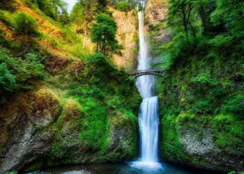
When travelling along the spectacular Columbia Gorge, it can now be difficult to imagine the many rapids and falls the expedition would have encountered. The Celilo Falls, a very important site for salmon fishing near the Dalles, is now completely submerged due to the Dalles Dam. The Cascades, where there were impassable sections of river, are now under Bonneville Dam.
The discovery of the Northwest Passage would soon change the United States beyond recognition as settlers started moving West swayed by the promise of free land.
Many deem Lewis and Clark to be heroes but equally, there are those who say this expedition was the beginning of the end for tribal people when settlers began to arrive. But visitors can relive the excitement of this adventure all along it, particularly apropos in this anniversary year.
Need to know
Getting There: For the start of the trail in St. Louis, there are international flights with most airlines from Heathrow and Manchester airports. These are via hubs such as Chicago O’Hare or Philadelphia International Airport and not direct.
Getting Around: If planning a road trip, book your hire car in advance. Remember, there will be an extra charge for picking up in one destination and dropping off in another. Make sure that you have full insurance cover and investigate third party sites to compare rates: bettersafe.com or carhireexcess.com
Time Zones: Central Daylight Time – St. Louis (GMT – 5); Mountain Daylight Time – Montana (GMT – 6); Pacific Daylight Time – Idaho and Oregon (GMT – 7)
Climate: Spring in the mid-west of the U.S. (including St. Louis) can mean turbulent weather (It isn’t called Tornado Alley for nothing) for which they are well prepared. Northern western states such as North Dakota, Montana or Idaho may still have wintry temperatures and even snow. For Oregon’s Temperate Pacific Coast, expect rain.
Accommodation: The Four Seasons Hotel in St. Louis has a new Gordon Ramsey restaurant and is walking distance from the Arch. The Hotel Elliot in Astoria, Oregon is a short drive from Fort Clatsop and the Historic Farr House offers rooms via Airbnb in Pierre, South Dakota.
For more information: traveloregon.com; greatamericanwest.co.uk; visitmo.com; nps.gov
About the trip
America As You Like It has a 21 night Lewis and Clark Trail fly-drive from £2,365 per person, based on two sharing on a room only basis including return flights, 21 days car hire with insurance ($250 one-way drop-off fee payable locally), and includes stays in St Louis and St. Charles, MO, one night in Omaha, NE, three nights in South Dakota, three nights in North Dakota, four nights in Montana, two nights in Lewiston, ID, two nights in The Dalles, Oregon and two nights in Astoria, Oregon.


